The Graves
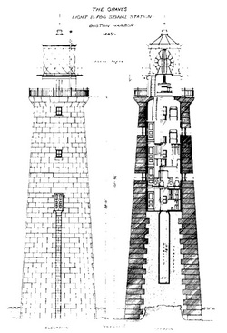
The Graves is an aggregation of rock outcroppings in Massachusetts Bay. Situated some 11 miles offshore of downtown Boston, it is the outermost island in the Boston Harbor Islands National Recreation Area. It is the location of The Graves Light, at 113 feet tall the tallest lighthouse in Boston Harbor, and an important navigation aid for traffic to and from the port. The island has a permanent size of 1.8 acres, and rises to a height of 15 feet above sea level; there is only aquatic vegetation on the island. The island is managed by the Coast Guard, and is not open to the public. The Graves are named after Thomas Graves, a prominent early trader of colonial Massachusetts.
The Graves are northeast of the Roaring Bulls and far northwest of Three and One-half Fathom Ledge. Despite their offshore location, the Graves are within the city limits of Boston. Source: Wikipedia-Graves
Shipwreck of the City of Salesbury on the Graves:
The weather was clear, Saturday, April 23rd, as Boston Pilot, Captain William H. Lewis guided the City of Salisbury toward the outer harbor. Bound for New York with a cargo estimated at nearly $2,000,000 the steamer was nearing completion of a 10,000-mile odyssey, which included stops in Calcutta, India, Ceylon, the Malay States, Halifax, Nova Scotia and now Boston. It had been a hard passage. Before leaving Calcutta a Himalayan bear had escaped. Later at sea a king cobra cannibalized its mate and at Halifax twenty-five monkeys escaped. What else could go wrong?
As Captain Lewis made his approach to Boston Harbor a thick fog bank engulfed the vessel. Although navigating in limited visibility was no simple matter then, or now, Lewis was confident of his position. Northeast of Graves Ledge Light, his Government charts showed plenty of water. Not long thereafter the steamer lurched to a halt.
The vessel had impaled itself on an uncharted pinnacle of rock, near the outer edge of Graves Ledge. Later the Coast Guard would clear Captain Lewis of any wrong doing, finding that Government Chart #246 was incorrect. The chart showed 33 feet of water, over which the steamer should have easily passed.
The freighter was in an awkward position. The pinnacle, over which the bow and stern hung, supported the ships midship section. Designed to be completely supported by water, the ebb and flow of the tide combined with a ground swell put undue stresses on the hull. Source: City of Salisbury Shipwreck at Graves
September 2013 - Graves Light has been sold to private citizen David Waller - Boston Globe Story HERE
Additional sources: Graves Lighthouse History
NE Lights lighthouse information
Additional photos added 10/2013 of tour of Graves Light in 10/2012, photos by Walter Hope
For the OFFICIAL web site of Graves Light click here: GRAVES